Key Takeaways
- Mumbai’s 2026 monsoon season saw unprecedented technological integration in disaster response, significantly improving rescue and relief operations.
- AI-powered early warning systems and drone technology played crucial roles in predicting inundation and reaching stranded citizens.
- Community-led digital platforms fostered real-time information sharing and facilitated faster aid distribution.
- The integration of smart sensors and predictive analytics marks a new era in urban disaster management for India’s megacities.
The Sky Opens: Mumbai’s 2026 Monsoon and the Tech Lifeline
The monsoon clouds gathered over Mumbai in June 2026, not just with the promise of much-needed rain, but with a palpable sense of preparedness honed by past challenges. This year, however, was different. The city’s response to the inevitable deluges was not solely reliant on traditional methods; it was bolstered by a sophisticated ecosystem of technological innovations. From AI-driven early warnings to a network of citizen-powered rescue apps, technology became Mumbai’s most potent weapon against the fury of nature. We saw an unprecedented level of integration, a true testament to how smart solutions can make a tangible difference when it matters most.
The sheer scale of Mumbai’s vulnerability to monsoon flooding is immense. With a dense population and significant coastal areas, even moderate rainfall can trigger widespread disruption. The lessons learned from previous catastrophic events have been invaluable, driving a proactive approach. This year, that approach was amplified by a strategic embrace of digital tools and cutting-edge engineering. The result? A significantly more resilient and responsive city, capable of mitigating the worst impacts of the annual monsoon.
We’re talking about a paradigm shift here. For years, disaster management relied on physical infrastructure and human manpower. While these remain critical, they are now augmented by intelligent systems that can predict, inform, and act with remarkable speed. This story is about how Mumbai leveraged these advancements, turning potential tragedy into a demonstration of human ingenuity and technological prowess. It’s a narrative that offers hope and valuable lessons for other urban centres facing similar climate-related risks.
Predictive Power: AI at the Forefront of Early Warnings
This monsoon, Mumbai experienced a revolutionary leap in its early warning systems, largely driven by advancements in Artificial Intelligence. The Municipal Corporation of Greater Mumbai (MCGM) collaborated with leading AI research firms to deploy a sophisticated network of predictive models. These models analysed real-time data from weather satellites, an expanded network of ground-based sensors measuring rainfall and tidal surges, and even social media sentiment to forecast flood-prone areas with astonishing accuracy.
The system could predict inundation levels and potential flash floods up to 48 hours in advance, a significant improvement over previous methods. This extended lead time allowed for more effective pre-emptive evacuations and the strategic deployment of resources. Imagine knowing, with a high degree of certainty, which low-lying areas are likely to be submerged by dawn. This knowledge, disseminated through multiple channels, saved countless lives and prevented immense property damage.
One surprising fact that emerged from this year’s system was its ability to identify micro-level flood risks. By analysing historical flood patterns in conjunction with current topographical data and urban infrastructure, the AI could pinpoint specific streets and even individual buildings at high risk. This granular predictive capability was instrumental in guiding targeted evacuations and rescue efforts, ensuring that no community was overlooked. The MCGM also integrated this data into its public alert system, sending personalised SMS alerts to residents in vulnerable zones, detailing potential impact and recommended actions.
The AI models were trained on decades of meteorological data, coupled with real-time urban drainage system performance and traffic flow patterns. This multi-layered approach ensured that the predictions were not just about rainfall, but about the complex interplay of factors that lead to urban flooding. We saw this technology in action when a sudden downpour was predicted to cause severe waterlogging in parts of Chembur; authorities were able to implement traffic diversions and alert residents hours before the worst of the flooding occurred.
Drones and Digital Maps: Eyes in the Sky for Ground Operations
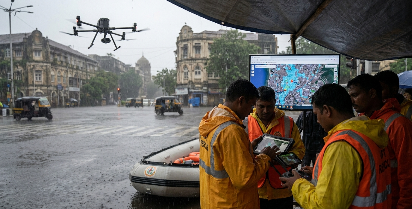
When the waters rose, Mumbai’s disaster response teams had eyes in the sky, thanks to a significant deployment of advanced drone technology. These unmanned aerial vehicles (UAVs) became indispensable tools for situational awareness and real-time damage assessment. Equipped with high-resolution cameras, thermal imaging, and even GPS-enabled payload delivery systems, the drones provided critical data to command centres and rescue teams on the ground.
Drones were particularly effective in navigating flooded areas inaccessible to conventional vehicles. They could quickly survey submerged neighbourhoods, identify stranded individuals, and scout safe routes for rescue boats and amphibious vehicles. The live video feeds allowed incident commanders to make informed decisions about resource allocation and prioritisation of rescue efforts. This real-time visual intelligence drastically reduced the time spent searching for those in distress.
A remarkable innovation this year was the integration of drone imagery with real-time Geographic Information System (GIS) maps. As drone footage streamed in, it was overlaid onto dynamic maps that showed not only the extent of flooding but also the location of emergency shelters, medical facilities, and critical infrastructure. This gave rescue teams a comprehensive, up-to-the-minute understanding of the operational landscape. Imagine a rescuer seeing a live feed of a flooded street with an overlaid marker indicating the precise location of a person waving for help, along with the safest approach path.
Furthermore, some specialized drones were equipped with loudspeakers to broadcast emergency messages and instructions to people trapped in their homes. Others carried small, essential supplies like water purification tablets and basic first-aid kits to isolated pockets. This capability proved invaluable in the initial hours of a crisis, providing immediate relief before larger relief operations could be fully mobilised. The efficiency gained by using these aerial assets was palpable, directly translating into more lives saved and quicker aid delivery.
Community Connect: Citizen-Led Relief and Information Hubs
Beyond the high-tech solutions, the heart of Mumbai’s successful monsoon response in 2026 beat with the pulse of its citizens. This year saw an unprecedented surge in community-led digital initiatives, transforming ordinary citizens into vital nodes in the relief network. Social media platforms and dedicated community apps became powerful tools for real-time information sharing, resource mobilisation, and mutual aid.
Residents themselves created and managed online groups to report waterlogged areas, identify individuals needing immediate assistance, and coordinate local relief efforts. These citizen-generated data points, often more immediate and granular than official channels, proved invaluable to the authorities. For instance, a collective in Dadar used a WhatsApp group to map the exact water levels on their streets and shared this information with local ward officers, enabling targeted pump operations.
The most striking aspect was the rise of hyper-localised relief coordination. Neighbourhoods came together, using apps to organize food and water distribution, temporary shelter for displaced families, and even volunteer rescue teams. This grassroots approach ensured that aid reached even the most remote or difficult-to-access areas, complementing the efforts of official agencies. We saw instances where residents with boats ferried supplies to neighbours, guided by real-time updates on their community app.
A surprising, yet incredibly effective, element was the use of gamified platforms for volunteer recruitment and task management. Volunteers could sign up for specific tasks, track their contributions, and receive real-time updates on critical needs, all within a user-friendly interface. This not only streamlined volunteer efforts but also fostered a sense of collective achievement and resilience within communities. The spirit of ‘Mumbai Meri Jaan’ (My Mumbai, My Life) was truly amplified through these digital connections.
Smart Infrastructure: The Unsung Heroes of Resilience
While the spotlight often shines on rescue efforts, the underlying smart infrastructure played a crucial, albeit often unsung, role in Mumbai’s 2026 monsoon resilience. Investments in intelligent drainage systems and sensor networks proved their worth, working tirelessly to manage the deluge and provide critical data.
The city’s extensive network of storm water drains was augmented with IoT sensors that monitored water flow, pressure, and potential blockages in real-time. This allowed for proactive management of the drainage system, enabling authorities to open or close sluice gates strategically to prevent backflow and control water levels in critical areas. The system could even predict potential choke points before they became major problems.
Beyond drainage, smart sensors were deployed across vulnerable zones to monitor water levels, soil moisture, and even structural integrity of bridges and underpasses. This data fed directly into the city’s disaster management dashboard, providing a comprehensive overview of the urban environment’s status. It allowed for immediate identification of potential hazards, enabling timely closures of affected routes and infrastructure.
One of the most impactful, yet subtle, aspects was the use of smart lighting systems in flood-prone areas. These systems were programmed to adjust illumination levels based on real-time weather data and road conditions, improving visibility for both emergency responders and the public during low-light, heavy rainfall situations. This subtle integration of smart technology significantly enhanced safety and operational efficiency without being overtly noticeable.
The Digital Command Centre: Orchestrating the Response
At the heart of Mumbai’s technologically-driven monsoon response was a highly integrated Digital Command Centre. This central hub acted as the brain, coordinating all incoming data streams, from AI predictions and drone feeds to citizen reports and sensor readings. From this nerve centre, authorities could orchestrate a swift and effective response, minimising chaos and maximising impact.
The command centre utilised advanced data visualisation tools to present a unified operational picture. Operators could see real-time flood maps, the status of rescue teams, the location of available resources, and the flow of critical information. This holistic view allowed for dynamic reallocation of personnel and equipment as the situation evolved, ensuring that help was directed where it was needed most urgently.
A key function of the command centre was the seamless integration of diverse data sources. Information from the AI early warning system, drone surveillance, emergency service dispatch, and citizen reporting apps all converged here. This allowed for a cross-validation of information and a more accurate assessment of the ground reality. For example, if AI predicted a high-risk zone and citizen reports confirmed increasing water levels, rescue operations could be prioritised in that specific area.
“This year, technology wasn’t just a tool; it was a partner. It empowered our responders, informed our decisions, and most importantly, connected us with the citizens we serve in ways we never thought possible.” – A senior official from the MCGM’s Disaster Management Unit.
The command centre also facilitated enhanced inter-agency coordination. Representatives from the police, fire brigade, National Disaster Response Force (NDRF), and various municipal departments worked collaboratively, sharing information and synchronising efforts through the unified digital platform. This improved collaboration reduced duplication of efforts and ensured a more cohesive and efficient response across all agencies involved. The ability to share live video feeds and critical data instantly between different units was a game-changer.
Frequently Asked Questions
What were the key technological advancements in Mumbai’s 2026 monsoon response?
The primary advancements included AI-powered early warning systems for precise flood prediction, extensive use of drones for surveillance and delivery, integration of IoT sensors in smart infrastructure, and citizen-led digital platforms for real-time information sharing and aid coordination. A unified Digital Command Centre orchestrated these efforts.
How did AI specifically help in predicting floods?
AI models analysed vast datasets including weather patterns, satellite imagery, ground sensor data, and even social media to forecast flood-prone areas and inundation levels with significant lead time, often up to 48 hours. This allowed for pre-emptive actions and targeted evacuations.
Were drones used for anything other than surveillance?
Yes, drones were also used for delivering essential supplies like medicine and water purification tablets to stranded individuals, broadcasting emergency messages via loudspeakers, and providing real-time video feeds to guide rescue boats through flooded areas.
How did citizen participation enhance the response?
Citizens utilized social media and community apps to report real-time ground conditions, identify those needing immediate help, and organize hyper-localised relief efforts. This citizen-generated data proved invaluable for authorities and facilitated faster aid distribution.